|
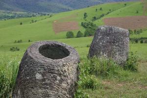
 As I didn’t manage to see a single jar plain yesterday I had to do all of the three main tourist ones today. The first and biggest plain of jars is just 6 kilometers from the city of Phonesavanh. Finding it should not be any problem if there were any maps available or if the local people (or the landlords) were able to explain where it was - nobody could however :(. At the end I found a travel office, where, even though the girl inside playing a computer game could not help me as she spoke no English, I found and photographed a hand drawn map containing all three sites I wanted to visit today. I then used my camera’s display and the magnification functions to orientate by it. As I didn’t manage to see a single jar plain yesterday I had to do all of the three main tourist ones today. The first and biggest plain of jars is just 6 kilometers from the city of Phonesavanh. Finding it should not be any problem if there were any maps available or if the local people (or the landlords) were able to explain where it was - nobody could however :(. At the end I found a travel office, where, even though the girl inside playing a computer game could not help me as she spoke no English, I found and photographed a hand drawn map containing all three sites I wanted to visit today. I then used my camera’s display and the magnification functions to orientate by it.
(For anyone who goes there and reads this, here is a direction how to get out of the city towards the plains: Just find the bank (turn right at the main T intersection in the city centre if coming from the west) and then turn right straight after the bank. Go straight on the wide divided street until you reach another T intersection, where you turn left. That’s it.)
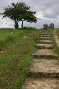
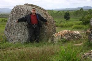
The first plain is reasonably well marked and you should not miss it (N19.43022 E103.15546). You pay 7000 Kip entrance fee and then you can have little  photo orgy if you like photography as I do. I had a very cloudy day unfortunately, but still the photos are quite good. photo orgy if you like photography as I do. I had a very cloudy day unfortunately, but still the photos are quite good.
The second and third plains are 27 and 32 kilometers respectively from the city. It is a dirt road on the second half of the way but it is a fun one on a good motorbike. When I first asked for directions I learned that I had already passed the Jarplain No.2 so I asked for directions to the number three. It was supposed to be very close but I still spent over an hour exploring the area and asking people and still couldn’t find it. Then I decided to head back, continuing on a narrow and very bumpy village road. I was hoping I might bump into the plain maybe. I asked for directions one last time at a petrol station back on the “main” road. They sent me 4 kilometers back again in the direction I just came from on my way back. And really, after two separate examinations of the little T intersection at about the specified distance I discovered a sign leading to the site no. 2. This sign is tiny and looks more like a local sign of no importance rather than a tourist sign. It is hand written too. That's why I missed it the first time.
 Couple of kilometers further and one more road split where one is uncertain which one of the roads to take I found a wooden shed with a ticket window (N19.32047 E103.15302) and an older woman inside it. I bought another ticket – this time for 4000 Kip – and had another photo spree. The second site is smaller but very pretty. Couple of kilometers further and one more road split where one is uncertain which one of the roads to take I found a wooden shed with a ticket window (N19.32047 E103.15302) and an older woman inside it. I bought another ticket – this time for 4000 Kip – and had another photo spree. The second site is smaller but very pretty.
As I had already spent over an hour looking for the site no. 3 I gave it a pass and returned to Phonesavanh. I was on my way back through the mountains and to Luangphrabang at 3PM. I knew I had no chance of arriving before dark but I didn’t want to loose another day, which would happen if I stayed in Phonesavanh for another night.
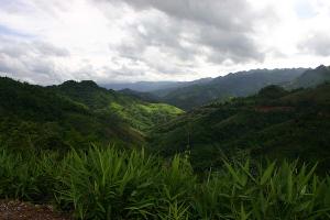
 The whole way to Luangphrabang the road was just an excellent motorbike ride, only maybe just a tiny bit too long. It took me over 6 hours to reach the world heritage city of Luangphrabang riding in an average altitude of 1300m the whole way before dropping to about 400 meters just a few kilometers before the city. It is about 260 kilometers from Phonesavanh. The whole way to Luangphrabang the road was just an excellent motorbike ride, only maybe just a tiny bit too long. It took me over 6 hours to reach the world heritage city of Luangphrabang riding in an average altitude of 1300m the whole way before dropping to about 400 meters just a few kilometers before the city. It is about 260 kilometers from Phonesavanh.
I found a two-dollar guesthouse again (Mixay, N19.88463 E102.13597) in a street that I originally thought was the main guesthouse street of the city. It is not but it is not too far from it at all. There was no message from the guys in my e-mail so I had a lonely dinner after after some time again and watched some Hollywood movie during it. Gee, I’d love to go to the movies…

(334km) |
Article thread follow options:
When you use the 'Next' or 'Previous' buttons on this page another article or set of articles will be displayed. What article(s) it will be depends on the options below.
|